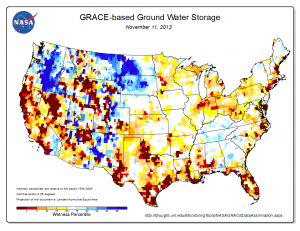
Map of groundwater storage percentiles, one of the drought indicators derived from GRACE satellite data (courtesy of NASA/Goddard).
A recent article in The Atlantic Cities highlighted a research paper published in Science by Jay Famiglietti, a professor of Earth System Science at the University of California, and Matt Rodell, Chief of the Hydrological Sciences Laboratory at NASA’s Goddard Space Flight Center. Famiglietti and Rodell use data from a new generation of Earth observing satellites from the Gravity Recovery and Climate Experiment (GRACE) mission to measure changes in groundwater availability globally. The researchers identify several areas across the United States that are currently suffering from drought and groundwater depletion, and show how GRACE could help detect and possibly predict such water-related catastrophes in the future.
The GRACE satellites are unique. Most satellites detect electromagnetic waves reflected or emitted from the Earth’s surface, but GRACE senses variations in the Earth’s gravitational pull by measuring changes in the speed and distance between two identical spacecraft flying in a polar orbit. As the twin satellites circle the globe together, regions of slightly stronger gravity will affect the lead satellite first, pulling it slightly away from the trailing satellite. By constantly measuring these changes in relative position, GRACE is able to construct a new gravity map of the Earth each month.
Since its launch in 2002, scientists have used GRACE to study everything from the mass balance of ice sheets to uplifting of the seafloor due to earthquakes. Famiglietti and Rodell’s study exploits GRACE’s ability to detect changes in the Earth’s gravity field caused by the redistribution of water on or beneath the land surface, including changes in groundwater, soil moisture, and snow. These measurements allow the authors to overcome the lack of comprehensive ground-based measurements of water storage and develop new insights regarding the potential for regional flooding and drought.
Droughts are amongst the costliest natural disasters, with average annual losses in the United States estimated to be in the range of $6 to $8 billion. Most experts expect these costs to rise in the future with climate change. In light of this, what’s the value of a technology like GRACE? In a new project, researchers from the University of New Mexico (Richard Bernknopf, David Brookshire, and Sara Pesko), Johns Hopkins University (Ben Zaitchik), NASA Goddard (Matt Rodell, one of the authors of the Science article), and RFF (Molly Macauley and myself) have teamed up to develop a framework for conceptualizing the value of information from GRACE. Specifically, we are analyzing how Earth observations from GRACE can help address one of the nation’s most difficult natural resource challenges: assessment of the onset and duration of droughts and their regional impacts.
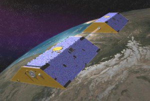
Artist's concept of the GRACE mission satellites (courtesy of NASA/JPL)
In order to get at the value of information from GRACE, we need to answer three main questions:
- How does information from GRACE improve drought monitoring?
- How does improved drought monitoring help farmers, water resource managers, and community drought planners make better decisions?
- Can these better decisions reduce the economic impact of droughts?
Our interdisciplinary research team will seek answers to these questions in two ways. First, we will conduct listening sessions with experts and stakeholders in order to obtain information about how GRACE has been incorporated into drought monitoring and reporting and how it can potentially be further incorporated. Second, we will undertake more formal modeling activities to characterize how GRACE-enhanced drought monitoring can improve regional economic outcomes. Stay tuned for new findings as we move ahead with this project!


